![](/images/other/stat-length.png)
![Tour Zu Fuß Claremorris-Swinford Municipal District - Foxford Way Loop - Photo](https://media.geolcdn.com/t/1900/400/3cb9a77b-d31f-42af-853d-c430271c9bca.jpeg&format=pjpeg&maxdim=2)
Foxford Way Loop
SityTrail - itinéraires balisés pédestres
Tous les sentiers balisés d’Europe GUIDE+
![Länge](/images/other/stat-length.png)
Länge
34 km
![Maximale Höhe](https://static1.geolcdn.com/siteimages/upload/files/1508320355ic_sort_altitude_max_24dp.png)
Maximale Höhe
261 m
![Positive Höhendifferenz](https://static1.geolcdn.com/siteimages/upload/files/1508320355ic_sort_den_pos_24dp.png)
Positive Höhendifferenz
654 m
![Km-Effort](/images/other/stat-length.png)
Km-Effort
42 km
![Min. Höhe](https://static1.geolcdn.com/siteimages/upload/files/1508320355ic_sort_altitude_min_24dp.png)
Min. Höhe
5 m
![Negative Höhendifferenz](https://static1.geolcdn.com/siteimages/upload/files/1508320355ic_sort_den_neg_24dp.png)
Negative Höhendifferenz
650 m
![Boucle](https://static1.geolcdn.com/siteimages/upload/files/16400158638029165_repeat_loop_refresh_sync_direction_icon.png)
Boucle
Ja
Kennzeichnung
Erstellungsdatum :
2025-02-06 12:38:56.785
Letzte Änderung :
2025-02-06 12:38:56.785
![Zu Fuß](https://static1.geolcdn.com/sitytour/trail-icons/100.png)
9h39
Schwierigkeit : Sehr schwierig
![Scannen Sie diesen QR-Code, um die Tour in der SityTrail-Anwendung zu öffnen](https://capi.geolives.com/qq0zvz2zws4bq2lad0pu/sitytour/trails/4342882/qr.png?size=200)
Kostenlosegpshiking-Anwendung
Über SityTrail
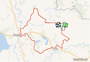
Tour Zu Fuß von 34 km verfügbar auf Unbekannt, County Mayo, Claremorris-Swinford Municipal District. Diese Tour wird von SityTrail - itinéraires balisés pédestres vorgeschlagen.
Beschreibung
Not to be confused with the "Foxford Way" 86km non-looped trail.
Website: http://www.mayotrails.ie/foxford.html
Ort
Land:
Ireland
Region :
Unbekannt
Abteilung/Provinz :
County Mayo
Kommune :
Claremorris-Swinford Municipal District
Standort:
Cuildoo ED
Gehen Sie:(Dec)
Gehen Sie:(UTM)
499962 ; 5982486 (29U) N.
Kommentare
Touren in der Umgebung
![Tour Zu Fuß Claremorris-Swinford Municipal District - Larganmore Loop - Photo](https://media.geolcdn.com/t/375/260/f51f1a27-86a6-4a34-9cde-89b2c06365b8.jpeg&format=jpg&maxdim=2)
![Zu Fuß Zu Fuß](https://static1.geolcdn.com/sitytour/trail-icons/100.png)
Larganmore Loop
Zu Fuß
Einfach
Claremorris-Swinford Municipal District,
Unbekannt,
County Mayo,
Ireland
![](/images/other/stat-length.png)
10,1 km | 13,7 km-effort
3h 7min
![](https://static1.geolcdn.com/siteimages/upload/files/16400158638029165_repeat_loop_refresh_sync_direction_icon.png)
Ja
![Tour Zu Fuß Claremorris-Swinford Municipal District - Prebaun Loop - Photo](https://media.geolcdn.com/t/375/260/3cb9a77b-d31f-42af-853d-c430271c9bca.jpeg&format=jpg&maxdim=2)
![Zu Fuß Zu Fuß](https://static1.geolcdn.com/sitytour/trail-icons/100.png)
Prebaun Loop
Zu Fuß
Einfach
Claremorris-Swinford Municipal District,
Unbekannt,
County Mayo,
Ireland
![](/images/other/stat-length.png)
9,5 km | 12,2 km-effort
2h 46min
![](https://static1.geolcdn.com/siteimages/upload/files/16400158638029165_repeat_loop_refresh_sync_direction_icon.png)
Ja
![Tour Zu Fuß Claremorris-Swinford Municipal District - Callow Loop - Photo](https://media.geolcdn.com/t/375/260/52e42cfb-0dd4-4eb0-b398-112e4210776b.jpeg&format=jpg&maxdim=2)
![Zu Fuß Zu Fuß](https://static1.geolcdn.com/sitytour/trail-icons/100.png)
Callow Loop
Zu Fuß
Einfach
Claremorris-Swinford Municipal District,
Unbekannt,
County Mayo,
Ireland
![](/images/other/stat-length.png)
6,4 km | 7,9 km-effort
1h 48min
![](https://static1.geolcdn.com/siteimages/upload/files/16400158638029165_repeat_loop_refresh_sync_direction_icon.png)
Ja
![Tour Auto Claremorris-Swinford Municipal District - j-6 Dublin - Photo](https://media.geolcdn.com/t/375/260/ext.jpg?maxdim=2&url=https%3A%2F%2Fstatic1.geolcdn.com%2Fsiteimages%2Fupload%2Ffiles%2F15247431544x4.jpg)
![Auto Auto](https://static1.geolcdn.com/sitytour/trail-icons/401.png)
j-6 Dublin
Auto
Sehr leicht
Claremorris-Swinford Municipal District,
Unbekannt,
County Mayo,
Ireland
![](/images/other/stat-length.png)
309 km | 336 km-effort
5h 20min
![](https://static1.geolcdn.com/siteimages/upload/files/16400158638029165_repeat_loop_refresh_sync_direction_icon.png)
Nein